
The Story Behind the Streets
In 2023, the Cumberland Land Trust acquired a new hiking trail known as the Catamint Brook Preserve. Located within an 84 acre space, the trail is comprised of 2.7 miles of paths that allow its hikers to take a peak into the past. The preserve is located within the Tower Hill Historic District of Cumberland, Rhode Island.
Two of the most heavily traveled roads within Cumberland, RI, are Mendon Road (State Route 122) and Diamond Hill Road (State Route 114). They were originally constructed in the seventeenth and eighteenth century and run northward from the south end of Cumberland. Connecting these two primary routes are several east-west roads; one of which is Tower Hill Road.
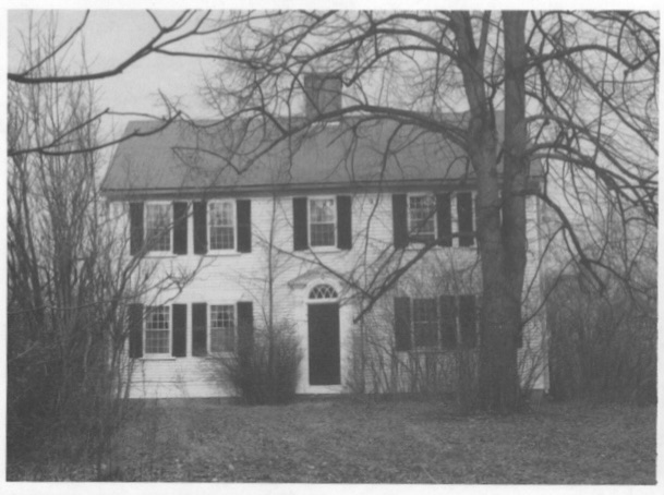
Tower Hill Road is decorated with many historical homes, one as old as 1797. The Miller House, located at 161 Tower Hill Road, is said to have likely been built by a woodcarver within the Tower family, and the home is known as the finest example of Federal architecture in the area. In 1838, the home was owned by a Jonathan Miller and this is presumably where it collected its name.
In addition to the Miller House, Tower Hill Road also envelops the antiquated Beacon Pole Hill, Tower Mine, Ballou-Weatherhead House, Follett House, a Schoolhouse Site, and the Fenner Grant House, among a few other unnamed properties.
The Path Unveiled: Exploring the Catamint Brook Preserve
For the remainder of this post, we will be focusing in on only what is accessible while walking the trail. This includes the aforementioned schoolhouse site and Beacon Pole Hill, as well as; an abandoned farmer’s dam and culvert, a field stone quarry, and the pitch pine grove associated with the beacon pole.
These landmarks are all identified on the map shown below.

We visited this trail shortly after the Cumberland Land Trust publicized its procurement. When I saw the description promoting the trail as having “many historic features”, we set off to check it out within days. Since Tower Hill Road’s main attraction is residential properties, if you don’t own a home on it, there’s not much reason to travel down it. The speed limit is -5mph (just kidding, like 20mph) and the road is narrow and windy. What was a destination approximately just 1.5 miles off the main road, ended up being a 5+ minute trip due to the caution one must spare when turning their wheel.
We took the lefthand turn off of Diamond Hill Road thinking we’d be unloading out of the car in a minute or two, but after nearly ten with no sign of the trailhead or lot, we assumed we had gone too far. After a brief debate over whether to continue onward or back-track, we made the decision to go just a bit further down the road. We made the right decision because it soon became clear we were parked just one road-bend away.
In summation: the Google Maps location for the Preserve is actually the historical Miller House down the street, and not the trail. It’s hard to miss the trailhead when you drive by it at -5mph so don’t fret if it feels like it’s taking longer than you expect to get there, and- take your corners slow. Many of them have low visibility of the oncoming cars.
Tips and Insights:
- The difficulty level of this trail is moderate. There are no paved paths, and there are quite a bit of inclines and declines.
- The lot is gravel and there are only about 8 unmarked spaces for vehicles. If the lot becomes full, there is no additional off-road space. Parking roadside is prohibited.
- There’s a portion of the trail that traverses through land where hunting is permitted. If you go into these woods during hunting season, plan to wear bright orange.
- Other portions of the trail run parallel to or even cross over private property. It’s an expectation that walkers remain on the labeled trail as to respect others’ land.
- This rule goes out the window when the trail requires you to cross over someone’s driveway. I think it’s safe to assume the owner agreed to this otherwise it wouldn’t be a thing.
- The yellow path is the main track but there are several optional paths that you can take for added difficulty and a higher viewpoint. The blazes are challenging but you won’t get lost, they will loop you right back onto the main path.
The Schoolhouse Site
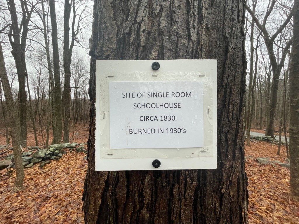
The Site of One Room School House is the first historical marker you will encounter on your walk. In fact, if you’re coming from Diamond Hill Road, you will actually drive by the plot moments before you turn right into the trailhead parking.
The schoolhouse was built in 1830 and was consumed by fire in the 1930’s. At this time, one-room schoolhouses in the United States were already beginning to decline as motorized school buses enabled longer commutes, making consolidation into larger schools more practical. By World War II, most one-room schools had been replaced, except in remote locations and rural communities. Whether by fire or another fate, it’d be unlikely that the schoolhouse would have seen the 21st century.
All that remains is a crumbling rock perimeter. It’s hard to image what this space would have looked like nearly two hundred years ago.

Beacon Pole Hill

George Washington (1732-1799) ordered the construction of many signal beacons during the Revolutionary War to warn citizens of British attacks. The beacons, made out of logs and brush, were designed to call out to militia, indicate the direction of British movements, and guide militia responses.
Rhode Island, specifically, had four beacons. These included Beacon Pole Hill in Cumberland, Prospect Hill in Providence, Mt. Hope in Bristol, and Chopmist Hill in Scituate. In these wooden structures were iron pots filled with pitch that could be lit to create a visible signal.
As indicated on the plaque, Beacon Pole Hill was was the highest point between the Blue Hills of Massachusetts and and Providence. It was positioned at 556 feet above sea level, making it ideal for visibility.
According to the Blackstone Valley Historical Society, Noah Ballou was initially tasked with maintaining and lighting the beacon pole, however, when Noah and his elder sons went to fight in the Revolutionary War, his 13-year old son, Elial Ballou, took over the responsibility. Elial managed the the beacon and responded to signals, including one from Providence requesting food for colonial troops. Elial made this delivery successfully using his oxen and cart to transport supplies.
There are no tangible remains of the beacon pole left, but it’s always intriguing to stand in a place where we know such significant history took place.

Pitch Pine Grove
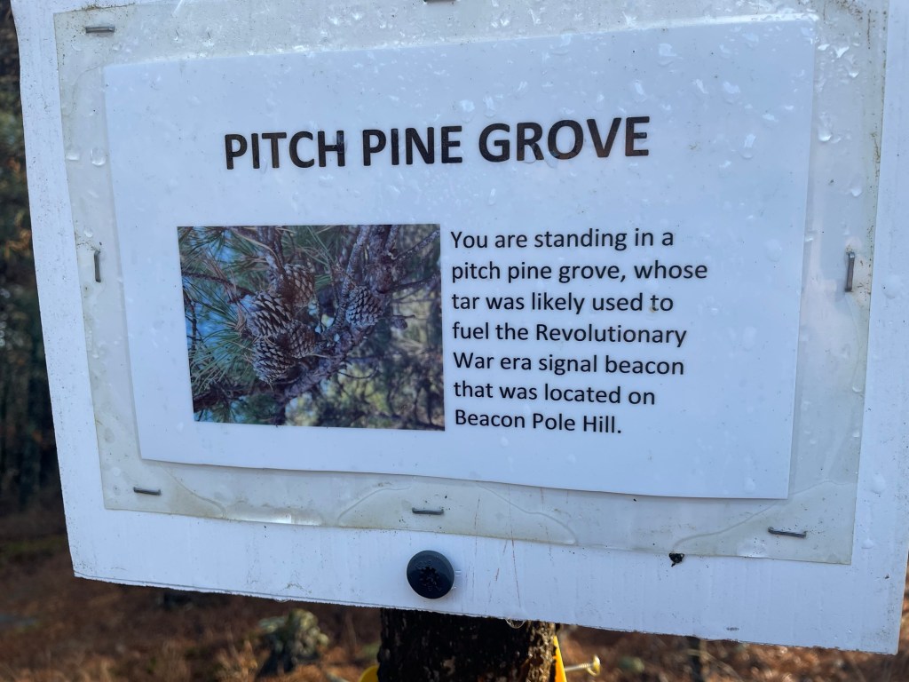
Conveniently located nearby where the beacon once stood is a decent sized grove of pitch pine trees. A pitch pine grove refers to a collection of pitch pine trees, which are native to eastern North America. Pitch pine groves were used for collecting pitch due to the tree’s high resin content, which made it ideal for producing pitch, tar, resin, and turpentine. These substances were essential for sealing wooden ships, among other uses during Colonial times. Resin was extracted by cutting channels in the trunk or through controlled combustion of the wood in kilns, where pitch was collected in surrounding ditches. This grove is believed to have supplied the beacon bucket with the pitch it needed to fuel a fire worthy of a large signal fire.

Farmer’s Dam and Culvert

The Cumberland Land Trust reports that both the dam and culvert on this path were established in the 1750’s.
Farmers in the 1750’s built dams and culverts primarily to manage water resources for agriculture and local industries. These structures helped redirect water for irrigation, enabling farming in areas with inconsistent rainfall or dry conditions. Dams also provided flood control, ensuring farmland was protected from seasonal flooding. Additionally, culverts and dams supported small-scale industries, such as powering mills for grain and lumber processing.
In these woods, there was also a quarry that was established within the same decade. It is unknown if the dam assisted with this operation as well, or if it mainly served as a resource for the farming community.

Farmer’s Quarry
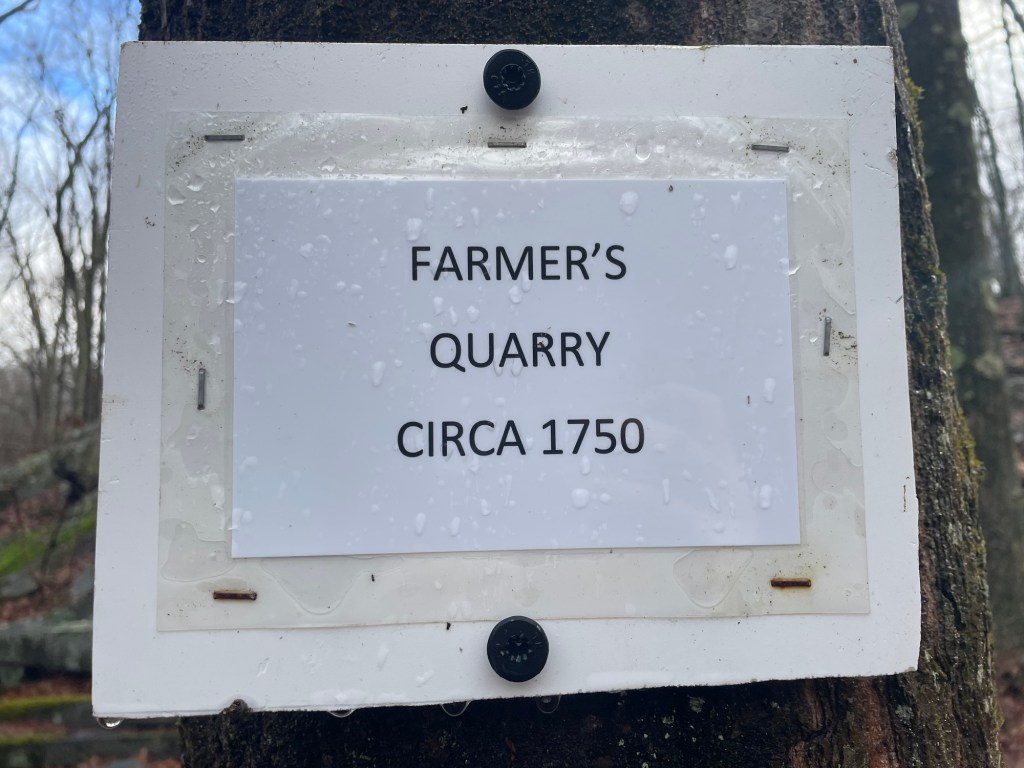
In some cases, farmers might operate quarries on their land to extract materials like stone, sand, or gravel, which can be used for construction or other purposes. The quarry on Tower Hill Road in Cumberland is part of the town’s rich history of mining and industrial activity. Cumberland is notable for its unique geological formations, including deposits of cumberlandite, iron ore, and other minerals that were extensively mined during the 18th century. Unlike other local quarries such as Iron Mine Hill and Diamond Hill, Copper Mine Hill and Tower Hill produced relatively low economic benefits.

Final Thoughts
As we conclude our exploration of the benefits of a moderate, picturesque walk that incorporates historical sites, it’s clear that such an experience offers a unique blend of physical well-being and cultural enrichment. The inclusion of antiquated landmarks adds a fascinating layer of depth, enabling us to learn about the past while enjoying the present.
Stay Curious,
– Karissa Boyer

Leave a comment